House Surveys Australia
HSA FAST
Find. AutoPrice. Schedule. Track.
Get an instant price for a Contour & Detail survey, book your week, and track the job through to delivery.
Enquire now to secure 10% off your survey
Get an instant quoteSurvey with us regularly? HSA FAST BUSINESS
Real pricing, right now
Priced from your actual lot size and the distance to site — a real figure in minutes, not a range and not a call-back.
Book a week that suits you
Choose from the survey weeks we have open and hold it with a deposit. The balance is invoiced on completion.
Tracked to delivery
Follow the job from booking through to the day your PDF and DWG land in your inbox. No chasing us for an update.
Not sure this is the survey you need? Everything below explains exactly what you get.
What is a Contour & Detail Survey?
A contour & detail survey captures the physical features of your site — ground levels, slope, trees, existing structures, fences, pits and other detail — and presents them as an accurate site plan with contour lines showing the fall of the land.
It's the foundation document your designer, architect or builder needs before they can prepare house plans, assess drainage, or plan earthworks and retaining.
Unlike a boundary survey, a contour & detail survey doesn't formally define your legal property boundaries — it focuses on what's physically on the ground. Most councils require one as part of a development application, so it's typically one of the first surveys ordered on a new build or major renovation.
How we capture your site
We survey the site with a laser scanner, which records millions of measured points — ground, buildings, fences, trees, kerbs and services — as a single three-dimensional model. Everything in the plan you receive is drawn from it.
A real scan from one of our jobs, decimated from 204 million points so it can be sent to a browser.
What you receive
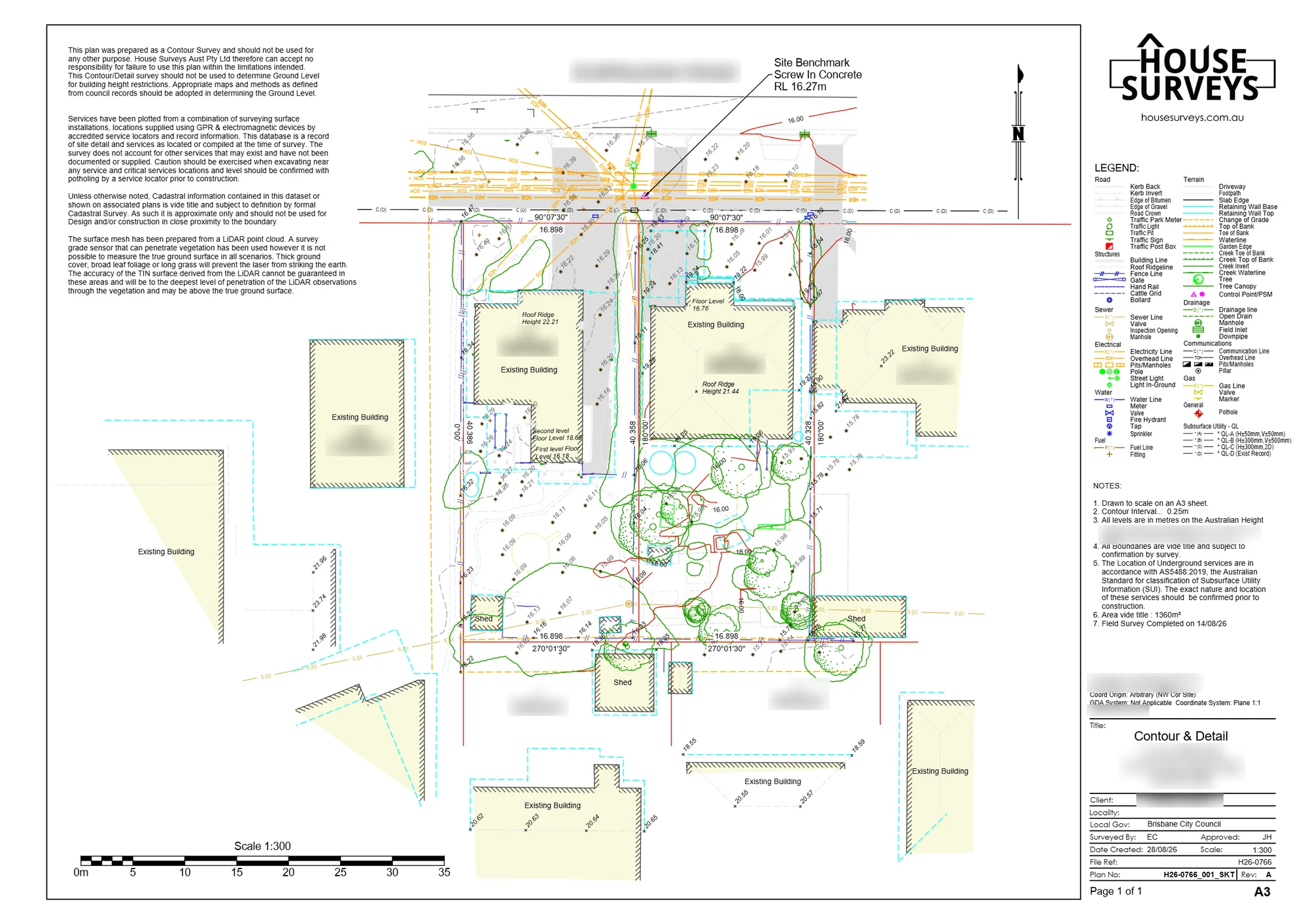
A completed Contour & Detail Survey plan, issued as both a PDF and a DWG (CAD) file your designer or drafter can work from directly. The plan shows contours at 0.25m intervals, spot levels, existing structures, services, trees and boundaries, drawn to scale on an A3 sheet.
What's included
Contour and Detail Survey
- Obtain registered survey information from Department of Resources.
- Attend site and connect to boundary reference marks to allow for property boundaries to be compiled (no allowance for marking of boundaries).
- Establish heights on Australian Height Datum (AHD) and place a Temporary Bench Mark (TBM) on site.
- Undertake Contour and Detail survey locating current ground surface (spot levels, changes of grade), visible services and invert levels where accessible, significant trees with diameter >300mm, corners of existing building(s) relative to boundaries, and ridge height and finished floor level of existing building.
- Locate adjoining dwellings directly facing the subject property within 5m of the common boundary (where visible).
- Locate landscape features including footpaths, driveways, fences and retaining walls.
- Locate the kerb-line on the side of the road closest to the subject site, including top and bottom of kerb and cross-overs.
- Scale in ground service alignments from BYD records.
- Provide a deliverable set including the Contour and Detail Survey plan in PDF and DWG format.
What's not included
Quoted separately if you need it
- Reinstatement or marking of property boundaries (also known as a Boundary Identification Survey).
- Engagement of a 3rd party service locator or potholing to identify in-ground service locations.
- Location of windows, doors, other openings, downpipes and the like on the subject site building or adjoining buildings, unless explicitly requested (additional fees apply).
- Definition or digitisation of Natural Ground Level (NGL) for the purpose of height limit determination in accordance with Local Government requirements — available as an optional add-on.
Optional add-on — Natural Ground Level Contours (NGL)
Using best evidence, determine and provide Natural Ground Level Contours (NGL) to calculate maximum height above ground level in accordance with Local Government requirements (DWG format). Councils often require this to assess building height, and it can be added to your quote before you book.
The instant price is for standard residential house lots. Unusually large, steep, heavily vegetated or complex sites are quoted individually — if yours is one of those, the form will tell you and our team will follow up.
Enquire now to secure 10% off your survey.